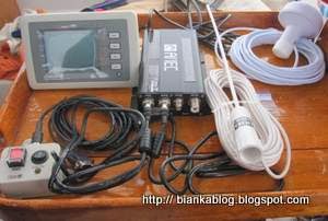
I installed an AIS transponder on board BIANKA two years ago. It seemed like a good idea to me. At times when sailing I've been surprised by a tug and barge sneaking up behind my at certain choke points like Execution Rocks on Long Island Sound. Situations that had me wondering now where did he come from? Having AIS gives you a heads up of where those BIG boats are and what they are doing. Having an AIS transponder lets those other boats know what you are doing or at least your name so they can call it out on the VHF. Instead of saying "white sailboat sailing southwest by buoy X. Also when navigating places like New York Harbor or the Hudson River it really comes in handy for both boats to make and see the subtle changes in course that eliminate the possibility of a collision. In short it gives everybody some piece of mind.
Recently on a foggy winters day off Long Island another very good reason for having an AIS transponder on board became clear. A tugboat named SEA LION was sinking rapidly off of Long Island coast in a thick fog. Captain Bjoern Kils of NY Media Boat was in the area on the boat APERTURE when he heard:
"MAYDAY. This is the ‘Sea Lion’. We’re sinking. Men in the Water.
Water in the wheelhouse. This is our last transmission. We’re going down." - NYMEDIABOAT
The Coast Guard rebroadcast the Sea Lions coordinates but, somewhere things got broadcast, copied or heard wrong:
"I wrote down the numbers and plotted the coordinates. The location showed close to Lake Champlain in upstate New York, about 180 miles to the north, making it unlikely that I was able to hear the actual radio transmission from the ‘Sea Lion’ so clearly. I deemed the given coordinates as improbable and started working my on-board navigation system pulling up a list of close-by ships. Most commercial vessels are outfitted with an AIS transceiver as part of an automated tracking and collision avoidance system, so chances are that they were still transmitting.
There she was! SEA LION — right on top of that list with a position only about two nautical miles to the south of my location. Putting down the throttle, we made it to the scene in just a few minutes, running 35 knots in 6-foot seas and less than 200 feet visibility." -NYMEDIABOAT
As Captain Kils said after the rescue:
“I think it's fair to say that the AIS system saved these guys’ lives,” Kils says. “The coordinates broadcasted by the Coast Guard were 180 miles to the north of the sinking vessel — I’m not sure why. By working my AIS system I was able to mark the Sea Lion’s actual location. Realizing I was only 2 nautical miles away from her position enabled me to respond, resulting in a rescue, not a recovery.”- SOUNDINGS
The crew of the Tugboat were very lucky to have been rescued so quickly in those frigid waters. While mistakes can happen when humans try to get out location coordinates in panicky emergency situations working electronic systems like AIS are dispassionate and will keep broadcasting the GPS coordinates until the power is lost. In this case it saved four lives. Thanks to Captain Kils and another boat in the area and having an AIS transponder on the sinking boat.
Tweet
AMEC CAMINO-101 Class B AIS Transponder
Garmin AIS 600 Automatic Identification System Transceiver w/ Programming
Raymarine AIS650 Class B Transceiver - Includes Programming Fee


.jpg)


No comments:
Post a Comment